Pulau Pinang (Penang Island)
State capital : George Town
Total area : 1,046.3 km²
State population : 1,503,000 (2007 estimate)
Population density : 1436.9/km² (2,031.74 people per km² on Penang Island and 865.99 people per km² in Seberang Perai)
Ruling party : Pakatan Rakyat ( People’s Pact )
Governor : Tuan Yang Terutama Abdul Rahman bin Haji Abbas
Chief Minister : Lim Guan Eng
State motto : Bersatu dan Setia (“United and Loyal”)
State Anthem (Malay) :
Selamat Tuhan kurniakan
Selamat Pulau Pinang
Negeriku yang mulia
Kutaat dan setia
Aman dan bahagia
Majulah jayalah
Negeriku yang kucinta
Bersatu dan bersama
Untuk negeri kita
National calling code : 04
National postal code : 10000 – 19500
Vehicle license plate prefix : P
Website : http://www.penang.gov.my/
State emblems
State animal : Bayan bird
State flora : Pinang tree
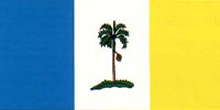
Flag of Pulau Pinang

The tricolor flag features vertical stripes of equal width with an areca nut tree on the white center panel. Light blue represents the sea surrounding the island; white stands for its serenity and yellow signifies prosperity. Pulau Pinang (Penang Island) derives its name from the areca nut tree, called pokok pinang in Malay.
Coat of arms of Pulau Pinang

The betel nut tree gave the island its name. The Penang Bridge is not only a source of pride to the people of Pulau Pinang; it also unites the island with the mainland part of the State, as well as symbolizing the unity between the State and the Federation. The two pillars of the bridge stand for two basic features of the New Economic Policy, namely the eradication of poverty and restructuring of society, while the four cables represent the four major races in the nation, that is Malay, Chinese, Indian and others. The five blue and white waves symbolize the five Rukunegara and the five administrative districts of the State. The five colors at the base of the betel nut tree have the same meaning.
Administrative Districts and Municipal Councils
These are the 5 districts and it’s municipal councils in Pulau Pinang:
- North East Penang Island
- Majlis Perbandaran Pulau Pinang
- South West Penang Island
- Majlis Perbandaran Pulau Pinang
- North Seberang Perai
- Majlis Perbandaran Seberang Perai
- Central Seberang Perai
- Majlis Perbandaran Seberang Perai
- South Seberang Perai
- Majlis Perbandaran Seberang Perai
Cities
These are the cities in Pulau Pinang:
- George Town (capital)
Towns
These are the towns in Pulau Pinang:
Penang Island
- Air Itam
- Balik Pulau
- Bandar Baru Air Itam
- Batu Ferringhi
- Batu Maung
- Batu Lanchang
- Batu Uban
- Bayan Baru
- Bayan Lepas
- Bukit Jambul
- Gelugor
- George Town
- Green Lane
- Gurney Drive
- Jelutong
- Paya Terubong
- Pulau Tikus
- Pulau Betong
- Sungai Ara
- Sungai Dua
- Sungai Nibong
- Tanjung Bungah
- Tanjung Tokong
- Teluk Bahang
Penang mainland
- Alma
- Bagan Ajam
- Bagan Luar
- Batu Kawan
- Bukit Mertajam
- Bukit Minyak
- Butterworth
- Ceruk Tok Kun
- Jawi
- Juru
- Kepala Batas
- Mak Mandin
- Nibong Tebal
- Pantai Aceh
- Permatang Pauh
- Perai
- Raja Uda
- Seberang Jaya
- Simpang Ampat
- Sungai Bakap
- Sungai Jawi
- Bukit Tambun
- Permatang Tinggi
- Val d’Or
Islands
These are the islands in Pulau Pinang:
- Pulau Aman
- Pulau Betong
- Pulau Gedung
- Pulau Jerejak
- Pulau Kendi
- Pulau Pinang
- Pulau Rimau
- Pulau Tikus
Townships
These are the townships in Pulau Pinang:
- Mount Erskine
- Minden Heights
- Taman Tun Sardon
